Showing posts with label hurricane season. Show all posts

Friday, September 11, 2015

This Week in Terrebonne History: Weather and Worn

Image of Nazi planes over London
Welcome to another This Week in Terrebonne History! This week we have low temperatures, hurricanes, and all the prices for shoes and cars throughout the years! Everything was gathered using the microfilm collection of Houma newspapers found in the main library's genealogy room. Come down and look through them, see what you can find!

September 9-13, 1940 - Houma Daily Courier

Headlines

  • "Mercury Hits 40-Year Low" - At a temperature of 31 degrees, Houma experienced its coldest September in 40 years.
  • "Nearly 5,000 Use the Parish Library During August" - The library had great numbers in 1940, according to librarian Patricia Motte.
  • "Special Rules for Traffic Announced" - Special paint was added to curbs and "Slow School" signs on Barrow Street to teach children to cross at crosswalks.

Movies

Market

  • A.M. and J. C. Dupont had shoes in all sizes from 89 cents to $5.00.
  • Terrebonne Motors was selling a used 1937 Ford "85" for $323.

Monday, August 31, 2015

Are You Prepared for a Hurricane?


The peak of hurricane season has arrived and with the 10th anniversary of Hurricane Katrina past and Hurricane Rita's on the way, it is best to take stock and make sure you and yours are prepared for any coming storm. While most everyone who lives on or near the gulf knows how to prepare and the best emergency routes for evacuation, it never hurts to go over the basics.

Thursday, September 1, 2011

Keeping an Eye on the Weather

A tropical storm appears to be brewing in the Gulf, and Terrebonne Parish may see some rain this weekend.

If you are concerned about flooding and possible evacuation orders, the Terrebonne Parish Government keeps a running list of any such alerts, which you can find by clicking here.

If you just want to keep an eye on the weather, this is a great time to check out the many features of the Weather Underground web site. At the Weather Underground main page, tap in your zip code where it says "Enter your location."

Click this link to check out the current forcast for Houma 70360.

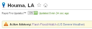
As the image to the right shows, we have a flash flood watch alert for our area at the time of this post.

A click on the "Flash Flood Watch" link to the right of the orange triangle brings up the most recent details released by the National Weather Service about that alert.

One of my favorite features of Weather Underground is the ability to see where the weather information is collected, and to choose the data collection station closest to you. You can even choose stations in the Gulf of Mexico.

Click on the "Station Select" button just under the blue Weather at a Glance bar. A map will appear that shows you the locations of nearby weather stations. The currently chosen station is in orange, and the rest are blue.

A click on any of the stations will reset the page to give you the weather and forecast for that spot.

For a broader choice of stations in your region, look below the radar image for a link to the WunderMap®

The WunderMap® can give you all sorts of information, including currently projected storm paths, using the many options listed to the right of the map. The weather stations are shown as colored circles with the current temperature listed inside. Mouse over any station for the name. Click on a station to see a pop-up window that provides current weather and forecast.

More to come on cool Weather Underground features in future posts!

- Jen Hamilton, Reference Services Supervisor

Tuesday, August 4, 2009

The Next Storm Surge: How High's the Water, Mama?


The LSU AgCenter, Louisiana Sea Grant and Bayou Interfaith Shared Community Organizing will be presenting "The Next Storm Surge" at the Terrebonne Parish Main Library on Monday, August 17 from 5pm-8pm in the large meeting room.

The presentation will include:

> Historical Hurricane Impacts on Coastal Louisiana; Factors Influencing Hurricane Storm Surge in Coastal Louisiana

> “What If” Hurricane Storm Surge Impacts on Terrebonne and Lafourche Parishes

> New Flood Zones: What They Mean and How They Will Impact You

This program was hosted at the Main Library last year and, since then, storm surge and wind-speed models have been updated, taking the impact of Hurricanes Gustav and Ike into account.

Lsu AgCenter staff will be available to help those in attendance access windspeed, ground level and storm surge models available online through the LSU AgCenter.

Attendance is free.

For information on other locations where this meeting will be held, follow this link:

Storm Surge Meetings, August 2009

Monday, June 1, 2009

Hurricane Season: Be Ready!


On June 1st begins Hurricane Season 2009. We all learned a tough lesson last year as Hurricane Gustav decided to make this area his target and sent many of us packing in a general evacuation.

Well, until November 30th, we're under the threat of hurricanes again, and it might be a good idea to read up on just how we can make ourselves more ready and thus safer this year.

Preparedness Links

Terrebonne Readiness and Assistance Coalition

Louisiana Governor's Office: Get a Game Plan

National Hurricane Center's "Be Prepared" Website

Louisiana Department of Transportation Contraflow Maps--Must be printed in "landscape."

The Department of Health and Human Services Hurricane Preparedness Tips

Hurricane Supply Checklist

The Red Cross Hurricane Evacuation Supply Checklist

Weather Monitoring

The National Weather Service's Hurricane Center

Stormpulse Hurricane tracking

NOAA Hurricane Tracking Chart--Print and use.